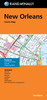
Rand McNally's folded map for New Orleans is a must-have for anyone traveling in and around this part of Louisiana, offering unbeatable accuracy and reliability at a great price. Our trusted cartography shows all Interstate, U.S., state, and county highways, along with clearly indicated parks, points of interest, airports, county boundaries, and streets. The easy-to-use legend and detailed index make for quick and easy location of destinations. You'll see why Rand McNally folded maps have been the trusted standard for years. - Regularly updated. - Clearly labeled Interstate, U.S., state, and county highways. - Indications of parks, points of interest, airports, county boundaries, schools, shopping malls, downtown & vicinity maps. - Enlargements of downtown. - Easy-to-use legend. - Detailed & full street index. - Orientation map. - Convenient folded size. Coverage Area Communities Included: Gretna, Harahan, Kenner, Laplace, Slidell, Westwego. Product Details: Measures 9.5' x 4' and folds out to 40' x 28'.
| Author: Rand McNally |
| Publisher: NA |
| Publication Date: Feb 22, 2024 |
| Number of Pages: NA pages |
| Language: English |
| Binding: T |
| ISBN-10: 0528029061 |
| ISBN-13: 9780528029066 |