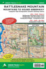
Rattlesnake ledge is one of the most popular hikes in the state. But there is so much more to Rattlesnake Mountain than the 2 mile trail to its famous ledges. The highest of the Issaquah Alps topping in at over 3500-feet, Rattlesnake contains more than ten miles of other trails leading to sweeping views, quiet forests, and a couple of summits. Our 205S map includes the entire mountain as well as the adjacent Raging River State Forest. This map also displays the upper Snoqualmie Valley Trail from Rattlesnake Lake to Fall City, Cedar Butte, Twin Falls Natural Area, Meadowbrook Farm, Tollgate Farm, the eastern half of the Preston-Snoqualmie Trail and the community trails on Snoqualmie Ridge. Map scale is 1:24000.
| Author: Green Trails Maps |
| Publisher: Green Trails Maps |
| Publication Date: Oct 01, 2024 |
| Number of Pages: 2 pages |
| Binding: Sheet Map, Folded |
| ISBN-10: 1680516523 |
| ISBN-13: 9781680516524 |